|
Ensuring Future Populations
Biologists from state, federal, and
provincial agencies conduct surveys each year to determine the status of
populations, evaluate habitat conditions, and to estimate harvest.
 Banding programs are used to estimate survival and migration patterns.
Surveys and banding programs are typically collaborative efforts among
agencies, but agencies also conduct independent surveys and banding
programs to meet agency-specific needs. Data are used cooperatively to
manage migratory game birds and play a paramount role in the annual
establishment of hunting regulations.
Banding programs are used to estimate survival and migration patterns.
Surveys and banding programs are typically collaborative efforts among
agencies, but agencies also conduct independent surveys and banding
programs to meet agency-specific needs. Data are used cooperatively to
manage migratory game birds and play a paramount role in the annual
establishment of hunting regulations.
Far too many surveys of migratory game birds exist to mention here, but
a few of the larger, coordinated surveys are mentioned below. Reports
from some surveys are available on the
Division of Migratory
Bird Management website of the U.S. Fish and Wildlife Service.
Population Surveys
Most migratory bird populations are monitored
through the cooperative efforts of biologists from state, federal,
and provincial agencies. Many of these surveys are
referenced in species, subspecies, and population-specific
management plans for the Pacific Flyway.
One of the more notable national surveys for webless migratory game
birds is the Mourning Dove Call-count Survey. The Service developed the
survey to provide an annual index to the size of mourning dove
populations by state and management unit in the United States. The
survey includes more than 1,000 randomly selected routes, stratified
 by physiographic region. The total number of doves heard on each route is
used to produce an index to breeding population size and determine
trends in populations.
by physiographic region. The total number of doves heard on each route is
used to produce an index to breeding population size and determine
trends in populations.
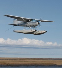
Breeding duck population size and production are estimated annually
during the Waterfowl Breeding Population and Habitat Survey, which is
conducted in May, and the Waterfowl Production and Habitat Survey, which
is conducted in July. These surveys are conducted using fixed-wing
aircraft and encompass principal breeding areas of North America, and
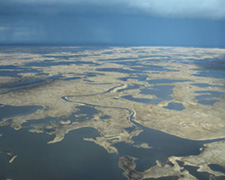
cover more than 2.0 million square miles. The traditional survey area
comprises 52 sampling areas across Alaska, Canada, and the north-central
U.S. and includes approximately 1.3 million square miles. The eastern
survey area includes parts of Ontario, Quebec, Labrador, Newfoundland,
Nova Scotia, Prince Edward Island, New Brunswick, New York, and Maine,
an area of approximately 0.7 million square miles.
The U.S. Fish and Wildlife Service and Canadian Wildlife Service
coordinate
assessments of the population status and productivity of
populations of Canada geese,
brant, snow geese, Ross’s geese, emperor
geese, white-fronted geese, tundra swans, and other migratory birds
in North America.
Biologists from state and federal agencies annually conduct the
Midwinter Waterfowl Survey to provide a measure of the relative numbers
or trends of duck populations. The survey identifies winter waterfowl
distribution and habitat use throughout the United States. The survey
also provides estimates of the size of goose and swan populations and
tracks population trends of duck species that nest outside of breeding
survey areas.
The North American Breeding
Bird Survey (BBS) is conducted annually to monitor the
 status and
trends of all North American bird populations. Following a rigorous
protocol, BBS data are collected by thousands of dedicated participants
along thousands of randomly established roadside routes throughout the
continent. Professional BBS coordinators and data managers work closely
with researchers and statisticians to compile and deliver these
population data and population trend analyses on more than 400 bird
species, for use by conservation managers, scientists, and the general
public.
status and
trends of all North American bird populations. Following a rigorous
protocol, BBS data are collected by thousands of dedicated participants
along thousands of randomly established roadside routes throughout the
continent. Professional BBS coordinators and data managers work closely
with researchers and statisticians to compile and deliver these
population data and population trend analyses on more than 400 bird
species, for use by conservation managers, scientists, and the general
public.
In addition to these continental and regional surveys, many local areas,
including federal wildlife refuges, state wildlife areas, and private
conservation areas, are monitored to determine the status of breeding
and wintering migratory bird populations.
Habitat Surveys
Primary continental waterfowl habitats are monitored
during the Waterfowl Breeding Population and Habitat Survey in May and the
Waterfowl Production and Habitat Survey in July. Biologists from federal,
provincial, and state agencies survey areas via fixed-
 wing aircraft to
evaluate the conditions of habitats in the north-central United States and
southern Canada. In addition, many regional and local surveys are conducted
to assess the condition and productivity of particular wildlife areas.
wing aircraft to
evaluate the conditions of habitats in the north-central United States and
southern Canada. In addition, many regional and local surveys are conducted
to assess the condition and productivity of particular wildlife areas.
Harvest Surveys
Two nationally coordinated surveys document harvest of
migratory game birds in the United States during the general season in fall
and winter: the
Migratory Bird Harvest Information Program (HIP), and the
Parts Collection Survey (PCS). Both surveys depend on collaboration
of the U.S. Fish and Wildlife Service with State wildlife agencies and
support by migratory bird hunters.
The HIP generates estimates of hunter participation and harvest. Hunters are
required to register for HIP before hunting swans, geese, ducks, coots,
gallinules, doves, band-tailed pigeons, woodcock, rails, snipe, and sandhill
cranes. Annual estimates of hunter participation and harvest are based on a
voluntary survey of selected migratory game bird hunters.
The PCS provides estimates of the composition of the harvest. A sample
of hunters from the HIP are provided special, preaddressed envelopes and
asked to mail in the wings (ducks, doves, pigeons) or tail feathers (geese)
of migratory game birds they shoot during the general hunting season.
Biologists meet annually at an event called a wingbee to determine the
species, age, and gender of the parts submitted by hunters. There is one
annual wingbee in each of the four flyways.
A third coordinated survey documents harvest of migratory birds in Alaska
during the spring-summer subsistence season: the
Harvest
Assessment Program (HAP). This survey also provides estimates of migratory
bird harvest during the general season in fall and winter in remote communities
in Alaska. The HAP is based on household in-person interviews and it is conducted
in collaboration among the U.S. Fish and Wildlife Service, Alaska Department of
Fish and Game, and Alaska Native local and regional partners through the
Alaska Migratory Bird
Co-management Council.
Banding
Bird banding is a universal technique for studying
the movement, survival, and behavior of birds, and is coordinated through
the North American Bird Banding Program. The
 program is jointly
administered by the U.S. Geological Survey through the
Bird Banding
Laboratory and the Canadian Wildlife Service through the Bird Banding
Office. These two offices do not band birds directly, but instead issue
banding permits, provide bands, maintain band and recovery data, and
coordinate banding projects in North America. The program supports banding
studies of federal and state wildlife agencies, the academic community,
professional and amateur ornithologists, and nongovernmental organizations.
program is jointly
administered by the U.S. Geological Survey through the
Bird Banding
Laboratory and the Canadian Wildlife Service through the Bird Banding
Office. These two offices do not band birds directly, but instead issue
banding permits, provide bands, maintain band and recovery data, and
coordinate banding projects in North America. The program supports banding
studies of federal and state wildlife agencies, the academic community,
professional and amateur ornithologists, and nongovernmental organizations.
The banding process involves capturing wild birds and marking them with
a uniquely numbered leg band. The bander records the band number, date,
and location of banding, the birds age and gender, and other information,
and sends that information to the Bird Banding Laboratory. Information
from bands subsequently found are reported to the Bird Banding Laboratory.
Banders may then learn about the characteristics of individuals and
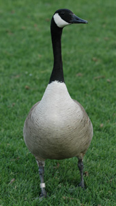 populations including movement, lifespan, survival, and other parameters.
Many research projects on migratory game birds also involve marking birds
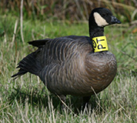
with color leg bands, neck collars, radios, and other auxiliary markers.
Such marking, also coordinated by the North American Bird Banding Program,
provides more detailed data on individual birds through their annual
travels.
populations including movement, lifespan, survival, and other parameters.
Many research projects on migratory game birds also involve marking birds
with color leg bands, neck collars, radios, and other auxiliary markers.
Such marking, also coordinated by the North American Bird Banding Program,
provides more detailed data on individual birds through their annual
travels.
Submit band recovery information using one of the following methods:
- Complete an
electronic
reporting form on the Bird Banding Lab Web site (reportband.gov)
- Call the Bird Banding Lab toll free at 800-327-BAND (2263)
- Write to the Bird Banding Laboratory (12100 Beech Forest Road,
Laurel, MD 20708-4037) and report the band number, how, when, and
where the bird or band was found.
- Contact your local state wildlife agency.
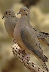
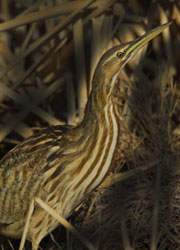
Photo credits: mourning doves, G. Andejko; float plane, T. Sanders;
Yukon Kuskokwim Delta landscape, T. Sanders; American bittern, G. Andrejko;
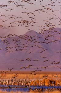
sandhill cranes, G. Andrejko; neckbanded cackling Canada goose, Andre Breault;
legbanded western Canada goose, T. Sanders.
|
